
The hike to Devil’s Bridge is 4 miles total round trip (2 miles out and 2 miles back) and should take about 40 minutes each direction, not accounting for the time spent at the bridge. The hike is relatively easy (and open with wide trails since part used to be a Jeep trail) until the last 0.25 miles when it starts to get more steep and challenging, giving it a total difficulty of moderate. Since the Devils Bridge is such a Sedona icon, it is known to get very crowded and incur hour long wait times once you arrive at the photo spot. To beat the crowds, get a sunrise (or earlier) start and plan to do this hike on a weekday (Friday or Monday for a long weekend trip).
Parking
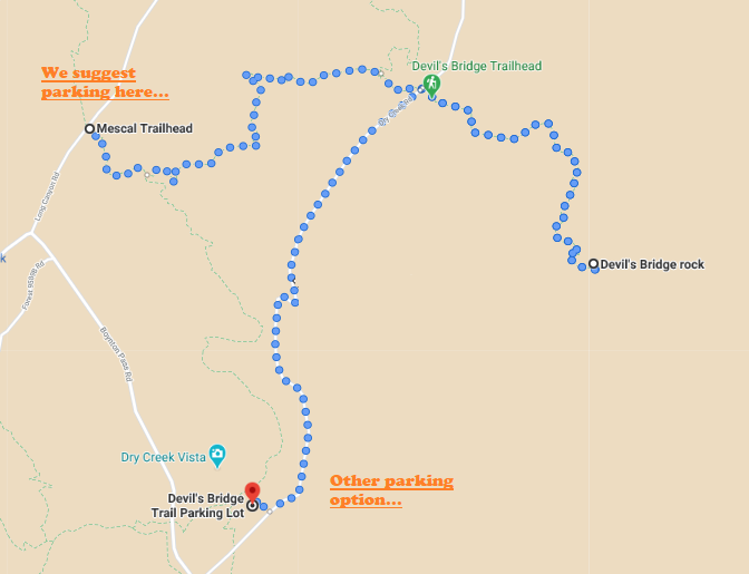
For parking there are 2 options: Devils Bridge Parking Lot or Mescal Trailhead Parking Lot – we suggest Mescal Trailhead. The Devils Bridge Trail Parking Lot can get very crowded and the first part of the hike from there is on a gravel road (not as enjoyable). For better views and less traffic (with the same total 4 miles hiking distance), park at the Mescal Trailhead parking lot on Long Canyon Road here.
The Hike
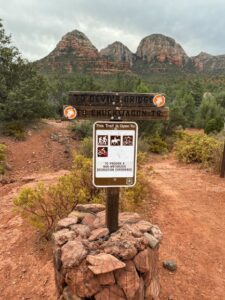
- Start and follow the Mescal Trail, you will see the sign above and know you are heading in the right direction. Follow the Mescal Trail for 0.2 miles until you reach Chuckwagon Trail.
- Turn to the left onto Chuckwagon Trail (it goes both ways, but you go left). Continue on Chuckwagon Trail for 0.8 miles (or about 15-18 minutes) until you run into Devils Bridge Trail on the right.
- Turn right onto Devils Bridge Trail. This is when you will merge with the people that took the gravel road from Devils Bridge Parking Lot. Continue on Devils Bridge Trail for 1 mile (about 25 minutes) until you reach your destination on the left.


Tips
There will likely (definitely) be a line when you get to the bridge – it is worth it to wait to get your picture on the bridge! Bring lots of water and snacks as you will be standing in the direct sun waiting.
(Word of advice: if you or someone in your group is willing to stand at the location where the photographers take the photos and take photos for everyone, you can speed the line up tremendously. That way there will always be someone walking onto the bridge as others walk off- you’ll see what I mean when you get there)
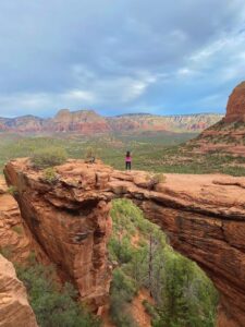
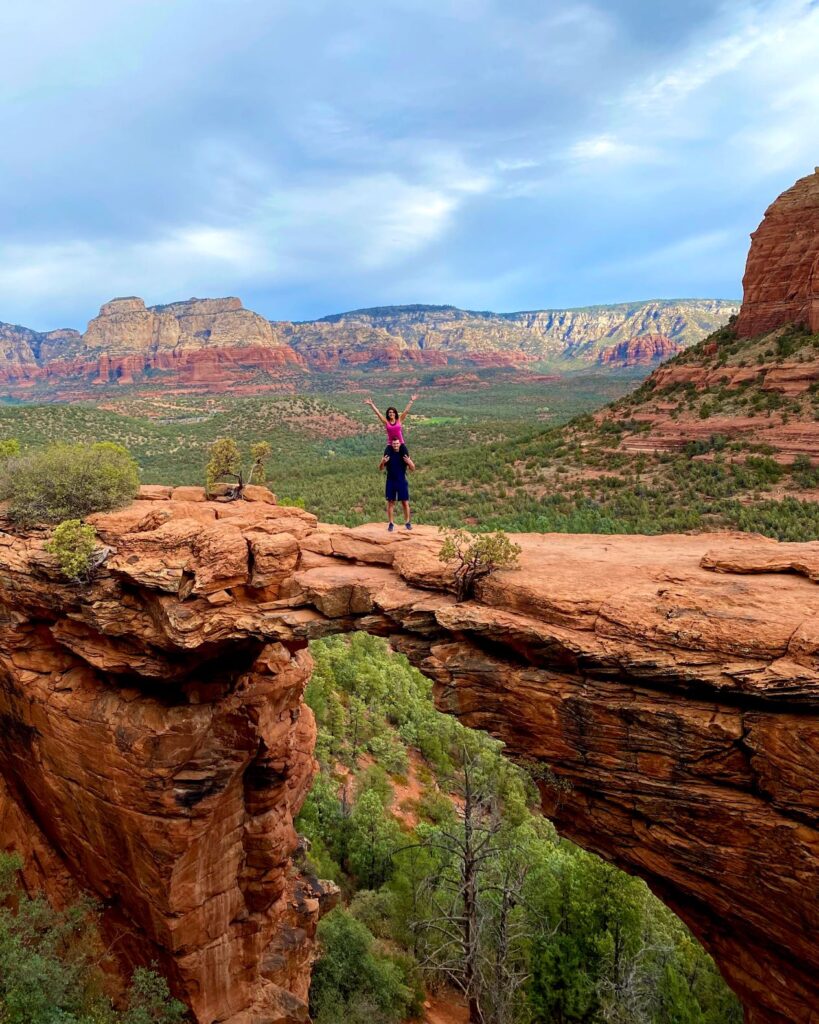
Fun fact: Although Devils Bridge is over 50 feet high with drop-offs on each side, it is 5 feet wide at its narrowest. So, if you can walk down a hallway (4 feet wide) without bumping into the walls, chances are good Devils Bridge won’t be a problem for you. It is actually more unnerving looking at it while waiting in line than it is walking on it.
Once you have taken in the views and have perfected every pose possible on Devils Bridge, it is time to take the hike back down. Prepare to stop and take in the breathtaking views on your way, they are endless. Remember when you are coming back and approach the gravel Jeep trail cut straight across to continue on Chuckwagon Trail toward Mescal Trail to your car. Ready for another hike? Check out our blog on Soldiers Pass Hike here!
In need of a full itinerary for your trip to Sedona? Check out our full blog here!